
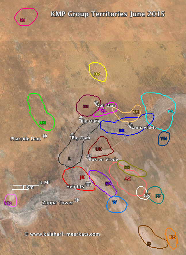
KMP Territory Map June 2015
The picture shows the approximate locations of the KMP’s current meerkat groups based on burrow usage during June 2015. The marked areas enclose the sleeping burrows used by the respective group during that period; territories (or “home ranges”) usually extend beyond the markings on the above map.
Note: The size of a group’s circle above has no direct relation to group size, or territory size – it just gives the group’s approximate location relative to other groups and the main landmarks at the KMP reserve. Groups that babysat pups in June 2015 used fewer burrows, resulting in a smaller size circle. Similarly, groups that were visited only few times produced fewer burrow data than frequently visited groups, again leading to a smaller size circle. Large blank areas between the marked territories are not monitored by the Kalahari Meerkat Project, i.e. they do not carry habituated meerkat groups.
Click on the links below for previous territory maps:
- June 2015
- June 2014
- June 2013
- June 2012
- May/June 2011
- December 2009
- January and February 2009
- February and March 2008
- November and December 2007
- July to September 2007
- 2004
Territory background
Over the past years, the Kalahari Meerkat Project monitored between 5 and 15 meerkat groups at any given time. Each group inhabits a home range, or territory, that is on average 0.5 to 1 square kilometer in size. This results in a population density of 5 to 17 meerkats per square kilometer.
It is not entirely clear what makes a good meerkat territory, even though food abundance and shelter (burrows, bolt holes) are thought to be important. In the KMP reserve, the meerkat groups either live in the usually dry riverbed of the Kuruman River, on flats, or in the dunes. The riverbed and flats offer more “bolt hole” refuges than do the dunes, which may decrease predation risk. The dunes offer more food though, at least in the rainy season. Meerkats seem to prefer the less productive, but less risky, riverbed or flats during the dry season, but they move to dune edges in the wet season, when an abundance of surface prey allows less risky, and more profitable, foraging there.
Territory shifts
Meerkat groups tend to remain in the same area, but territory shifts do occur over time, for various reasons. The below visualisation shows the burrow usage of 20 of the main (i.e. long-term) KMP groups between 2002 and 2011, as far as burrow use data have been available for this visualisation.
Click on this link to view the visualisation.
Group codes: AZ = Aztecs, B = Balrog, BB = Baobab, CD = Commandos, D = Drie Doring, E = Elveera, F = Frisky, G = Gattaca, JX = Jaxx, KF = Kung Fu, L = Lazuli, M = Moomins, R = Rascals, SQ = Sequoia, TY = Toyota, V = Vivian, VH = Van Helsing, W = Whiskers, YO = Young Ones, Z = Zappa.
![]()
![]()
Sources:
Population dynamics in meerkats, Suricata suricatta – Andrew Bateman, PhD thesis, University of Cambridge, 2013.
Habitat use, ranging behaviour and social control in meerkats – A. Turbé, PhD thesis, University of Cambridge, 2006.
Meerkat territory visualisation: Dr. Nicolas Perony, ETH Zurich